WHY GEYLANG ?
Previously in our blog we talked about the public demanding for a mixed used zone urban planing thereby obtaining short distance transit to work and closeness of living spaces to convinces.
Instead of planning a whole new town in this ideal, there are already existing towns like this in Singapore such as:
Geylang
Hougang
Joo Chiat
Chinatown
Kampong Gelam
Jalan Bersa
Lavender
Bugis
This blog entry we will examine Geylang.
This is a satellite image from google earth show predominant clay roof tiles in the Geylang area.
The satellite map makes more sense once you identify the East West MRT Line
Wherever you are in Geylang, you always have access to 3 MRT station and need to walk about 500m to 1km at the most. The entire stretch of Geylang is somewhere between 5 to 6km long.
Some of the most highest
concentration of MRT stations reside in the South Eastern part of Singapore.
The reason is simple, this was the historically dense area before 1953 where
Bukit Merah Road was not built yet and passage into the west was more
difficult. They existed before the concept of high rise public housing (HDB).
The towns-cape are mostly low rise and dense. The modernization of Singapore was
to address the ills created by these low rise shop-houses. It created
overcrowding, transit and sanitary issues.These issues have since been resolved
because family of 4 don't live in a 2 x 2m space anymore, there is no more
unlicensed street hawkers disposing soil water on the streets.
Geylang circa 1956 picture taken from National Archives.
Before independence Geylang existed on the commerce created by the tramp way that connected bedok jetty to the city and much latter the proximity to the Kallang Airbase which brought about the red light district. Before the world of television, Happy World an entertainment park and the Singapore Badminton Hall was a popular draw for the community.
Before independence Geylang existed on the commerce created by the tramp way that connected bedok jetty to the city and much latter the proximity to the Kallang Airbase which brought about the red light district. Before the world of television, Happy World an entertainment park and the Singapore Badminton Hall was a popular draw for the community.
Unlike Chinatown, Geylang did not have the squalid texture of Chinatown in the 1920's because it was still developing in response to the tramlines but the tramlines closed down suddenly in 1927 and were replaced by trolley buses. The re-emergence of development happen when Kallang Air Base was developed in 1937. World War 2 era saw the end of trolley buses in 1940. By this time Geylang's commerce and urban form has already benefited from the trolley bus and air base bustle.
Royal Air Force personnel pass in front of a B-24 Liberator aircraft at Kallang airport, Singapore, in 1945-46.
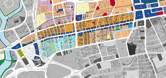
This is the master-plan of how Geylang is zoned
Geylang has a very good spread of commercial activity near residential areas. There is good proximity to work areas being institutional, commercial, industrial literally. The transit at the most 2 MRT station stops. A commercial spine spans between recreational river walk to the commercial Paya Lebar Hub. Suddenly, Geylang is the most sort after environment to be in. Just a short walk or a bicycle ride and you are at home, or having a meal, shopping or going home. Ideally a 1 km walk wont hurt much.
So what about the red light district ? Over the years since 2007, the red light industry has moved largely to the casino and gone online. They are fast evolving with the emergence of social media translating their trade into massage parlour and pub meet ups. URA suggest a conversion of 40% commercial use in the traditional red-light areas and this is promoting a change in the red -light activity.
So there you have the future city for Singapore (made from the past):
1. Short public transport trips
2. Walking distance to work and play
3. High proximity to commercial use
4. High Mixed use environment
5. Close to industrial activity will be the new economy
1. Short public transport trips
2. Walking distance to work and play
3. High proximity to commercial use
4. High Mixed use environment
5. Close to industrial activity will be the new economy
not to forget
6. Geylang is also not far from the airport than other estates
7. Low rise building means less mechanical maintenance disruption and cost
7. Low rise building means less mechanical maintenance disruption and cost
8. at the moment low rentals and more affordable private property ownership
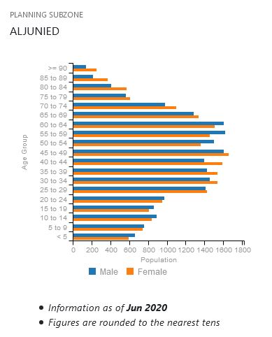
A look at demographics provided by URA shows a high concentration of baby boomers, Gen X and Y community.
This means everyone can fit in and the existing infrastructure caters for everyone unlike Seletar which are heavy on Baby Boomers or Sengkang which has high Gen X community.
A quick comparison between Seletar Hills, Fernvale (in Sengkang) and Tagore (in Angmokio) should show you that the population profile forms a unique fingerprint of the people there !

Perhaps Geylang is a real masterpiece after all
You may want to read about urban change post pandemic


Comments
Post a Comment